Urban3 completed a public asset valuation analysis for Salt Lake County in which publicly owned land was mapped according to its property value. When it comes to development opportunities, public land is often overlooked because it is accumulated over time and tracking the supply and value of that land loses priority over the years. Urban3 identified and performed valuation analysis on the 44 square miles of viable public land, worth over $10B.

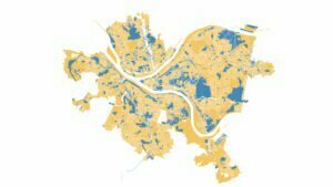
Planning for development on public land requires more than identification and valuation. Strategically locating projects close to public transit is important to building a well-connected city that sustains property value productivity. About 9 square miles of public land exists within a five minute walk to a Salt Lake light rail station. New development is feasible on about 6 square miles of that land. Feasible in this sense means that the land is underutilized, on suitable terrain, and has little community importance. When mapped, strategic development areas are revealed with public land in blue, a 5 minute walk radius in gold, and light rail stations in red.
Outcomes
- Urban3’s work facilitated the convening of different land owning public entities around the idea of leveraging real estate assets to meet common goals like creating affordable housing.
- Salt Lake County now understands the scale and scope of publicly owned land and created a database to manage it.
- After the analysis, Salt Lake County selected sites for redevelopment based on Urban3’s site recommendations.